Learn Jeppesen Charts: Simple, Fast, Effective
Jeppesen charts are the industry standard for aviation navigation, providing pilots with crucial information for safe and efficient flight. However, mastering their intricacies can seem daunting to newcomers. This comprehensive guide breaks down the process of learning Jeppesen charts into simple, fast, and effective steps, equipping you with the knowledge to confidently interpret this vital flight information.
What are Jeppesen Charts?
Jeppesen, a Boeing company, produces a wide range of aeronautical charts and publications, but their most recognizable product is their collection of charts used for flight planning and in-flight navigation. These charts provide detailed information including:
- Airport diagrams: Showing runways, taxiways, frequencies, and other airport infrastructure.
- Enroute charts: Depicting airways, navigation aids (VORs, NDBs, etc.), and terrain features.
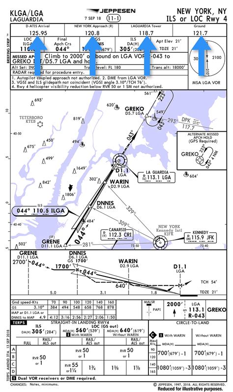
- Approach plates: Detailing instrument approach procedures to specific runways.
- Terminal area charts (TACs): Providing a detailed view of the airspace surrounding an airport.
Understanding these different chart types is crucial for effective navigation.
How to Effectively Learn Jeppesen Charts
Learning Jeppesen charts is a progressive process. It's best approached systematically rather than trying to absorb everything at once. Focus on understanding the core concepts before moving on to the more nuanced aspects.
1. Start with the Basics: Understanding Chart Symbols and Abbreviations
Jeppesen charts utilize a standardized system of symbols and abbreviations. Mastering these is paramount. Begin by familiarizing yourself with the legend provided on each chart. Pay close attention to:
- Runway markings: Understand how runway numbers are determined and what the various markings (e.g., thresholds, displaced thresholds) indicate.
- Navigation aid symbols: Learn to identify VORs, NDBs, ILS, GPS approaches, and their associated frequencies.
- Airspace designations: Understand Class A, B, C, D, E, and G airspace and their associated restrictions.
- Terrain elevation: Learn how to interpret contour lines and understand minimum safe altitudes.
Numerous online resources and Jeppesen's own publications offer detailed explanations of these symbols.
2. Practice, Practice, Practice: Working with Sample Charts
The best way to learn is by doing. Obtain sample Jeppesen charts (many are available online for practice purposes, though you should not use these for actual flight planning) and practice identifying key information. Try to:
- Identify runways and their associated procedures.
- Locate navigation aids and determine their frequencies.
- Plan a simple flight route using the enroute charts.
- Interpret approach plates for a specific airport and runway.
This hands-on approach will solidify your understanding of the chart symbols and their application.
3. Utilize Online Resources and Training Materials
Jeppesen itself, along with numerous flight schools and online aviation resources, offer training materials and courses specifically designed to teach Jeppesen chart interpretation. These resources often include:
- Interactive tutorials: Allowing you to explore charts and practice identifying key elements.
- Practice exercises: Testing your understanding of chart symbols and procedures.
- Videos and webinars: Providing visual explanations of complex concepts.
Taking advantage of these resources significantly accelerates the learning process.
4. Seek Mentorship: Learn from Experienced Pilots
If possible, seek guidance from experienced pilots or flight instructors who are proficient in using Jeppesen charts. Their expertise can offer invaluable insights and practical tips. They can help you navigate the complexities and answer your specific questions.
Frequently Asked Questions (FAQs)
What is the difference between a sectional chart and a Jeppesen chart?
Sectional charts are general aviation charts showing terrain, airports, and navigation aids. Jeppesen charts are more detailed and tailored for specific flight procedures, including approach plates and airport diagrams. Sectional charts are a good starting point for learning general aviation navigation, while Jeppesen charts are essential for instrument flight.
Are Jeppesen charts only for professional pilots?
While professional pilots heavily rely on Jeppesen charts, they're also used by private pilots, especially those undertaking instrument flight. The level of detail and precision offered makes them invaluable for safe and efficient flight planning.
How do I access Jeppesen charts?
Access to Jeppesen charts typically requires a subscription through their website or authorized distributors. Several mobile apps also provide access to Jeppesen chart data.
What are the most important things to remember when using Jeppesen charts?
Always cross-reference information from multiple sources. Understand the limitations of the charts and always maintain situational awareness. Never rely solely on a single data source for critical flight decisions.
By following these steps and dedicating consistent effort, you can effectively learn to use Jeppesen charts, a crucial skill for any serious aviator. Remember that consistent practice and understanding the underlying principles are key to mastering these essential tools for safe and efficient flight.

